
Quick answer
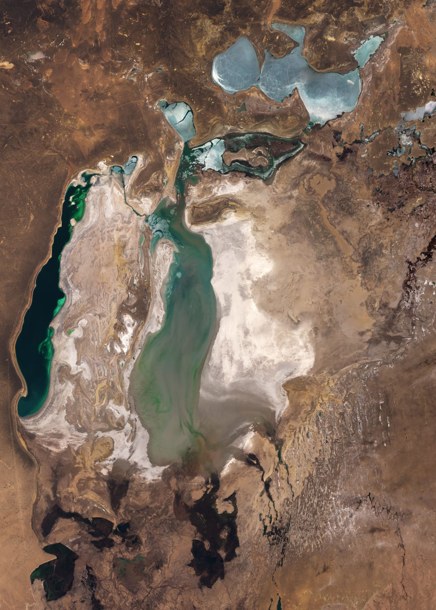
Is the Aral Sea growing? The North Aral Sea has stabilized and grown modestly since the Kok-Aral Dam completion in 2005, with water levels rising approximately eight meters and surface area expanding by several hundred square kilometers. The South Aral Sea continues to contract, with its eastern lobe now a seasonal salt flat. Overall, the sea remains at roughly ten percent of its 1960 volume, and full restoration is not projected under current inflow conditions.
The Aral Sea once ranked as the fourth-largest lake on Earth, covering 68,000 square kilometers between Kazakhstan and Uzbekistan. By the early 2000s, Soviet-era irrigation diversions had reduced it to fragmented remnants, exposing 54,000 square kilometers of lakebed and earning it recognition as one of the planet's starkest environmental collapses. Visitors who ask whether the Aral Sea is growing encounter a divided answer shaped by engineering, hydrology, and political borders. The North Aral Sea, also called the Small Aral, lies entirely within Kazakhstan and receives inflow from the Syr Darya River. The Kok-Aral Dam, a thirteen-kilometer dike completed with World Bank support, separated the northern basin from the declining southern zone and allowed water to pool rather than drain southward into evaporating shallows. Within three years of the dam's closure, the North Aral's surface rose eight meters, salinity dropped by half, and native fish species returned to support a renewed commercial catch. Satellite imagery confirms continued stability, with the northern shoreline holding near its post-dam configuration and seasonal fluctuations tied to snowmelt rather than long-term decline. The South Aral Sea tells a different story. Fed by the Amu Darya, which now rarely reaches the lake due to upstream cotton irrigation in Uzbekistan and Turkmenistan, the southern basin has split into eastern and western lobes. The eastern lobe desiccated completely by 2014, leaving behind a hypersaline crust visible from orbit. The western lobe persists as a shallow, shrinking body with salinity levels approaching 110 grams per liter—three times that of ocean water. No large-scale infrastructure project comparable to the Kok-Aral Dam serves the southern basin, and regional water policy prioritizes agricultural output over ecological inflow. Restoration discourse often conflates the two basins, leading to confusion when media report recovery milestones. Growth in the North Aral Sea is real but localized, representing a fraction of the original lake's extent. The ship graveyard at Moynaq, Uzbekistan, sits nearly two hundred kilometers from the current southern shoreline, a distance that grows wider each year. Visitors planning trips to the region should clarify which basin they intend to see: the stabilized northern waters near Aralsk or the retreating southern edge accessible from Nukus. Both offer stark testimony to the limits of large-scale water diversion, but only one shows signs of reversal.
“The North Aral Sea has stabilized and grown modestly since the dam's completion, but the South Aral continues its retreat across the Uzbek desert.”
Understanding the Current State: Is the Aral Sea Growing?
The Aral Sea is not growing as a single body of water, but rather exhibits divergent outcomes between its northern and southern regions. Understanding its current state requires distinguishing between managed restoration efforts and the arid reality of the desiccated basin.
North Aral Sea partial recovery
The completion of the Kokaral Dam in 2005 successfully stabilized and raised water levels in the North Aral Sea. This structure prevents water from flowing into the southern basin, allowing the northern section to maintain a more consistent volume.
South Aral Sea continued desiccation
The South Aral Sea remains largely cut off from its primary river sources and continues to experience evaporation and shrinking. It has fragmented into smaller, highly saline water bodies that lack the hydrological support needed for significant growth.
Hydrological separation of basins
The northern and southern basins act as distinct hydrological systems following the construction of permanent barriers. While the North shows signs of ecological stabilization, the South faces ongoing challenges related to its isolation from the Syr Darya river flow.
Surface area volatility
The water surface area in the southern region remains highly sensitive to annual weather patterns and fluctuations in upstream water usage. Significant expansion is not occurring, as evaporation rates frequently exceed the minimal inflow provided by groundwater and seasonal runoff.
Salinity levels and ecological impact
Increased salinity in the remaining southern waters renders the environment unsuitable for most native fish species that were historically present. This high salt concentration is a direct consequence of the basin's inability to circulate or replenish its volume at historical rates.
Basin depth and volume realities
Total volume across the entire original basin remains a small fraction of its 1960 capacity. While localized areas may experience minor seasonal depth increases, the overarching trend for the South Aral Sea is one of long-term contraction.
The Environmental Context Behind Is the Aral Sea Growing
The Aral Sea once ranked as the world's fourth-largest lake, fed by the Amu Darya and Syr Darya rivers descending from Central Asian highlands. Soviet planners in the 1960s diverted both rivers into vast irrigation canals to transform desert into cotton and rice fields. By 1987 the sea had split into northern and southern basins. The southern lobe, straddling Uzbekistan, receded faster; by 2014 satellite imagery confirmed its eastern basin had vanished entirely for the first time in modern history. The question is the aral sea growing hinges on which fragment a visitor examines: the North Aral, dammed by Kazakhstan in 2005, has stabilized and even risen several meters, while the South Aral continues to shrink. Salinity in the southern remnants now exceeds 100 grams per liter, ten times the toxicity threshold for most fish. Winds lift salt and pesticide dust from the exposed seabed—roughly 54,000 square kilometers of new desert—and deposit it across farmland hundreds of kilometers away, a process geologists term aeolian redistribution. The port of Moynaq, once a bustling harbor, now lies more than 150 kilometers from the nearest shore. Rusted trawlers rest in the sand, artifacts of an inland fishery that harvested 40,000 tons annually until the early 1980s. Restoration of the Aral Sea remains partial: engineering interventions have rescued the northern sector, yet the southern basins face structural water deficits as upstream agriculture still consumes the bulk of river flow. Visitors today confront this duality—a cautious recovery in one basin, irreversible loss in another—etched into a landscape where ship graveyards and salt flats mark the contours of what was once continuous water.
Logistics for Visitors Asking Is the Aral Sea Growing
The Aral Sea is located in remote regions of Uzbekistan and Kazakhstan, with the most accessible approach from the city of Nukus. Reaching the former shoreline requires traversing vast desert terrain where paved roads often transition into unmarked tracks.
4x4 vehicle from Nukus via Muynak
Private hire vehicle with experienced desert driver
Regional transport to Muynak, followed by 4x4 transfer
Best Time to Visit While Investigating Is the Aral Sea Growing
The optimal period to visit the Aral Sea region is during the spring months of April and May or autumn months of September and October. These windows offer moderate temperatures, avoiding the extreme heat of summer and the freezing conditions of winter, which are essential for safe travel through the desert.
April – May
MinimalMild, 15°C to 25°C
Spring offers stable ground conditions and pleasant temperatures for exploring the remote shoreline and ship graveyards.
September – October
LowCool, 10°C to 20°C
Autumn provides clear visibility and comfortable weather, making it ideal for navigating desert terrain.
06:00–19:00
——
Daylight is essential for navigating remote desert terrain and ship graveyard sites.
Verdict: The best time to visit is during April or October, strictly adhering to the daylight window of 06:00–19:00 for safety.
Entrance Fees for Those Asking Is the Aral Sea Growing
The Aral Sea natural area is a public region with no official entrance fee. Visitors may encounter varying costs when accessing specific regional museums or facilities located near the site.
A typical visitor pays 0 USD to enter the Aral Sea area, though costs will vary based on optional museum visits.
Visiting Hours for Exploring If Is the Aral Sea Growing
The Aral Sea natural area remains accessible 24 hours a day, seven days a week. While the area is always open, safety requires visitors to plan their excursions during daylight hours.
| Monday | 00:00–23:59 | |
|---|---|---|
| Tuesday | 00:00–23:59 | |
| Wednesday | 00:00–23:59 | |
| Thursday | 00:00–23:59 | |
| Friday | 00:00–23:59 | |
| Saturday | 00:00–23:59 | |
| Sunday | 00:00–23:59 |
Check availability
Frequently asked questions about is the aral sea growing
Everything you need to know about is the aral sea growing