
Quick answer
The Aral Sea is not completely gone, but it has shrunk to roughly 10 percent of its 1960 surface area. The southern basin in Uzbekistan, once the larger body, is now a shallow, heavily saline remnant. The North Aral Sea in Kazakhstan has partially recovered due to dam construction, while vast stretches of former seabed lie exposed as the Aralkum Desert. Visiting the region today means encountering a landscape of salt flats, rusted fishing vessels, and dry harbors.
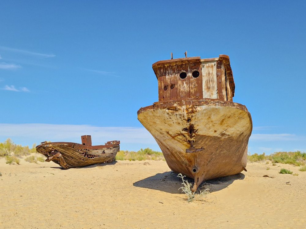
The Aral Sea occupies a position unlike any other body of water on earth: it exists as both a geographic feature and a cautionary symbol. Soviet-era irrigation projects diverted the Amu Darya and Syr Darya rivers to cotton fields across Uzbekistan and Kazakhstan, draining the sea's tributaries and triggering a collapse that began in the 1960s and accelerated through the end of the century. By 2014, satellite imagery confirmed that the eastern lobe of the southern basin had dried completely for the first time in modern history. The question of whether the Aral Sea is gone hinges on how one defines a sea. Water still exists in isolated pockets: the North Aral Sea, sustained by a dike completed in 2005, has stabilized at roughly 40 percent of its 1960 extent and supports a modest fishing industry. The southern basin retains a shallow western lobe, but salinity levels exceed those of ocean water, rendering it biologically barren. Between these fragments lies the Aralkum, a man-made desert of salt, dust, and agricultural chemicals that now covers more than 50,000 square kilometers of former seabed. Visitors arriving in Muynak, once a thriving port city on the southern shore, find themselves standing 150 kilometers from the nearest water. The ship graveyard—a cluster of decaying trawlers marooned in the sand—has become the region's most recognized landmark, a tangible measure of how far the shoreline has retreated. The exposed seabed is accessible by vehicle, though the terrain is uneven and the air carries salt and dust. Photography is unobstructed, and the scale of the environmental disaster becomes legible only when standing in what was, within living memory, deep water. The Aral Sea's disappearance is not a closed chapter. Seasonal rains occasionally fill shallow depressions in the Aralkum, creating temporary salt lakes that evaporate within weeks. Restoration efforts in Kazakhstan have demonstrated that partial recovery is possible under specific hydrological conditions, but the southern basin remains beyond meaningful intervention. What persists is a landscape that documents the limits of resource extraction and the permanence of large-scale environmental damage.
“By 2014, satellite imagery confirmed that the eastern lobe of the southern basin had dried completely for the first time in modern history.”
Historical Context: Why Is The Aral Sea Gone?
Until the mid-twentieth century, the Aral Sea ranked as the world's fourth-largest lake, fed by the Amu Darya and Syr Darya rivers that flowed from the mountains of Central Asia. Soviet planners viewed the basin as an inefficient use of water. In 1918, Lenin approved the first large-scale irrigation schemes to transform the Karakalpak and Kyzylkum desert into cotton and rice fields. By the 1960s, the pace accelerated: the Karakum Canal, completed in 1988, became the longest irrigation canal on earth, diverting the Amu Darya westward into Turkmenistan. The Syr Darya was similarly tapped for cotton monoculture across southern Kazakhstan. The two rivers no longer reached the sea in meaningful volumes by 1975. Salinity doubled, then tripled. Commercial fishing collapsed by 1982; the last cannery in Muynak closed in 1986. The seabed, now exposed, released salt and agricultural chemicals into the air, poisoning cropland hundreds of kilometers downwind. By 2000, the lake had split into fragmented remnants—North Aral, South Aral, and several ephemeral pools. The South Aral Sea effectively disappeared by 2014, leaving only a thin seasonal brine in the deepest basin. Is the Aral Sea gone in a functional sense? Yes: what remains is a fraction of the 1960 surface, disconnected from its historic tributaries. Today, visitors to Muynak stand on former seabed sixty kilometers from the nearest water. Rusted trawlers rest in the sand where fishermen once unloaded catches. The ship graveyard, preserved by the desert climate, marks the shoreline as it stood in the 1970s. The desiccation continues: seasonal rainfall briefly fills shallow depressions, but the permanent body of water that justified the name Aral Sea no longer exists.
Lenin approves large-scale irrigation projects to convert the Aral basin into agricultural land.
Soviet engineers accelerate water diversion; the Amu Darya and Syr Darya are redirected into canals serving cotton monoculture.
River inflow to the Aral Sea drops below evaporation rates; the lake begins continuous shrinkage.
Commercial fishing in the Aral Sea collapses as salinity rises and fish stocks vanish.
The last fish cannery in Muynak closes; the port is abandoned as water recedes.
Completion of the Karakum Canal, the world's longest irrigation canal, further drains the Amu Darya.
The Aral Sea fragments into separate northern and southern basins, with no connection between them.
The South Aral Sea's eastern lobe dries completely, leaving only a shallow seasonal pool in the western basin.
How To Reach The Aral Sea From Nukus
The Aral Sea is located in the Muynak District, Karakalpakstan, Uzbekistan, and is accessed primarily by traveling from Nukus. Because the region features remote desert terrain, a 4x4 vehicle is necessary to navigate the unpaved tracks beyond the town of Muynak.
Nukus to Muynak via A380 and 4K-562 road
Nukus to Muynak (private hire)
Muynak to Aral Sea shore (4x4 required)
When Is The Best Time To Visit If The Aral Sea Is Gone?
The spring and autumn months offer the most favorable climate for visiting the Aral Sea region, providing relief from the extreme seasonal temperature fluctuations of the desert. Planning your arrival for the early morning window ensures optimal light conditions for photography and comfortable exploration.
Spring (April–May)
Low to moderateMild with temperatures 15°C to 25°C
This period avoids the intense summer heat and facilitates comfortable desert travel.
Autumn (September–October)
Low to moderateCooler with temperatures 10°C to 20°C
Stable conditions make this an ideal time for extended photography sessions in the landscape.
Summer (June–August)
LowVery hot, often exceeding 40°C
High temperatures necessitate careful planning and increased water consumption.
Daily Arrival Window
Negligible—
The best arrival window is 06:00–10:00, providing optimal lighting for photography and cooler temperatures in the desert climate.
Verdict: The best time to visit is during April or October, ensuring you plan your arrival for the 06:00–10:00 window.
Opening Hours For Areas Where The Aral Sea Is Gone
The public territory where the Aral Sea was formerly located is accessible to visitors at all times throughout the week.
| Monday | 00:00–23:59 | |
|---|---|---|
| Tuesday | 00:00–23:59 | |
| Wednesday | 00:00–23:59 | |
| Thursday | 00:00–23:59 | |
| Friday | 00:00–23:59 | |
| Saturday | 00:00–23:59 | |
| Sunday | 00:00–23:59 |
Check availability
Frequently Asked Questions: Is the Aral Sea Gone?
Everything you need to know about is the aral sea gone